J. Ocean Eng. Technol. Search

CLOSE


J. Ocean Eng. Technol. > Volume 38(2); 2024 > Article
Van Dang, Joo, Lim, Hur, and Shin: Numerical Model Test of Spilled Oil Transport Near the Korean Coasts Using Various Input Parametric Models

Abstract

Oil spills pose significant threats to marine ecosystems, human health, socioeconomic aspects, and coastal communities. Accurate real-time predictions of oil slick transport along coastlines are paramount for quick preparedness and response efforts. This study used an open-source OpenOil numerical model to simulate the fate and trajectories of oil slicks released during the 2007 Hebei Spirit accident along the Korean coasts. Six combinations of input parameters, derived from a five-day met-ocean dataset incorporating various hydrodynamic, meteorological, and wave models, were investigated to determine the input variables that lead to the most reasonable results. The predictive performance of each combination was evaluated quantitatively by comparing the dimensions and matching rates between the simulated and observed oil slicks extracted from synthetic aperture radar (SAR) data on the ocean surface. The results show that the combination incorporating the Hybrid Coordinate Ocean Model (HYCOM) for hydrodynamic parameters exhibited more substantial agreement with the observed spill areas than Copernicus Marine Environment Monitoring Service (CMEMS), yielding up to 88% and 53% similarity, respectively, during a more than four-day oil transportation near Taean coasts. This study underscores the importance of integrating high-resolution met-ocean models into oil spill modeling efforts to enhance the predictive accuracy regarding oil spill dynamics and weathering processes.

1. Introduction

Maritime shipping of oil and hazardous and noxious substances (HNS) has become a prominent economically advantageous means of long-distance transportation rather than alternative modes. Therefore, the quantity of oil and HNS transported by marine shipping increases substantially, placing a high risk of spill accidents in overcrowded marine traffic zones. Despite the declining trend in the number of tanker spills, the escalating volume of loaded tanker trade suggests a continuous increase in tanker transportation and density, raising the potential for significant spill accidents involving substantial oil and HNS leakage into the marine environment (ITOPF, 2020). South Korea, a major hub for marine transport, has witnessed a series of historic spill accidents. According to the Korean Coast Guard (KCG) White Paper (KCG, 2021), approximately 9,000 accidents and 65,000 kL of spilled oil occurred between 1993 and 2020. Although the number of oil spill accidents has fluctuated over the past 28 years, oil spill accidents significantly impact ecosystems and socioeconomic assets. Therefore, developing a scientific risk assessment framework is necessary to mitigate the effects of oil spills. Hence, the accurate prediction of oil slick transport is paramount to achieve this. When tanker accidents occur, a significant amount of crude oil is released, forming oil slicks as thin layers floating on the sea surface. The fate and movement of these oil slicks are greatly influenced by the baseline environment characteristics and processes. For example, the 2007 Hebei Spirit accident, which was considered one of the worst spill accidents in Korea, occurred near the Taean coasts and resulted in the discharge of approximately 10,900 t of heavy crude oil into the ocean. The adverse weather, characterized by strong winds and currents, was attributed to the quick spread of the oil slick, leading to extensive contamination along the southeast coasts of the Korean Peninsula.
Numerous numerical models designed to predict the movement of oil spills have proven to be highly effective in rapidly determining the trajectories of spilled oil transport. Accurately forecasting the oil slick transport is a primary finding of numerical models, enabling authorities and relevant agencies with sufficient information to decide a quick response regarding optimizing search, rescue, and cleanup operations. Over the past decades, significant advances in the development of oil spill models have been conducted to simulate the oil slicks, such as DELFT3D (e.g., Abascal et al., 2017), MEDSLIK-II (e.g., De Dominicis et al., 2013), and GNOME (e.g., Jung and Son 2018). On the other hand, most of these numerical models are commercial software that challenges users to modify and configure the source code to suit specific conditions. Thus, a dynamic numerical model has been developed to predict the fate and trajectories of spilled oil over time.
In the current study, OpenOil, an open-source code model, was used to model oil spill transport and fate. The OpenOil model was implemented within the OpenDrift platform and programmed in Python, providing a flexible environment that allows users to adapt and incorporate several modules based on specific purposes. Moreover, the numerical models operate by considering various input met-ocean parameters, including winds, waves, and currents, standing for fundamental components that influence the trajectory of oil slick transport in the marine environment. As a result, the precision and reliability of met-ocean conditions are paramount in evaluating the predictive performance of oil spill numerical models. The parameters characterizing ocean currents are derived from hydrodynamic ocean-circulation models, providing water characteristics that affect the transport of spilled oil on the ocean surface (De Dominicis et al., 2016). The wind velocity and air properties can be assessed using meteorological models that can consider the oil evaporation of floating oil (Keramea et al., 2023). Wave models offer valuable information on wave parameters, including Stoke-drift fields, significant wave heights, and wave periods, which can influence the turbulent and vertical mixing process. Therefore, the forcing data were selected as input parameters based on the objective of each oil spill simulation. The current study focussed on simulating the trajectories of spilled oil on the surface. The primary forcing parameters encompass winds, waves, and currents. Consequently, integrating high-resolution ocean currents, meteorological, and wave models is imperative in oil spill numerical models to ensure the precise estimation of the fate and trajectories of oil slicks.
The principal objective of this study was to use the OpenOil model coupling with the available met-ocean forcing models, specifically currents, winds, and waves, to simulate the 2007 Hebei Spirit oil spill accident. For this purpose, hydrodynamic ocean current data were received from the Hybrid Coordinate Ocean Modeling (HYCOM) and Copernicus Marine Environment Monitoring Services (CMEMS). Various meteorological models, including CMEMS, Climate Forecast System Reanalysis (CFSR), Fifth Generation of the European Reanalysis from the European Centre for Medium-Range Weather Forecasts (ECMWF-ERA5), and Korean Local Analysis Prediction System (KLAPS), were used to extract the wind fields and air temperature. Furthermore, the CMEMS wave models derive wave characteristics for the significant wave height, wave period, and Stoke-drift velocities. The met-ocean forcing models were organized into six combinations to investigate the most influential input variables in predicting oil diffusion in the 2007 accident. The predictive performance of each combination was validated using satellite-observation data of the oil slick at 11 am on December 11, 2007.
The remainder of the paper is organized as follows. Section 2 comprehensively describes the OpenOil simulation model and met-ocean conditions. Section 3 presents a numerical setup and input parameters of the Hebei Spirit oil spill accident. Section 4 reports the numerical results of different combinations validated using the SAR dataset. Finally, Section 5 presents the conclusions and discussions for further work.

2. Met-Ocean Conditions and OpenOil Model

2.1 Meteorological Models

The National Centers for Environmental Prediction (NCEP), administered by the National Oceanic and Atmospheric Administration (NOOA), provides a climate forecast system analysis model (CFSR accessed at https://www.hycom.org/dataserver/ncep-cfsr), which comprehensively represents the dynamic interactions between atmosphere, oceans, and land surfaces from 1992 to now. The CFSR model generates an hourly time-step dataset with a spatial resolution of 1/2°. French-McCay et al. (2021) applied CFSR wind fields to simulate the oil trajectory and fate of the Deepwater Horizon from April to September 2010. Moreover, the wind dataset derived from the CFSR model was used to conduct 896 oil spill simulations to establish a risk assessment framework in the Perdido region near the Gulf of Mexico (Meza-Padilla et al., 2021). In addition, the fifth-generation ECMWF Reanalysis-ERA5 (https://cds.climate.copernicus.eu/cdsapp#!/dataset/reanalysis-era5-single-levels?tab=overview) provides hourly wind-forcing reanalysis data presented in regular longitude and latitude grids at a spatial resolution of 1/4°×1/4 °. The eastward and northward velocity fields measured 10 m above the still water level were collected from 1940 to the present and updated daily. Zhang et al. (2020) tested the ERA5 wind forcing to model the drift trajectories in the South China Sea. The ERA5 meteorological fields were also applied to simulate oil spill movement and behavior in the busiest shipping routes through the Gulf of Suez, Egypt (Abdallah and Chantsev, 2022). Moreover, the CMEMS proposed the global ocean hourly reprocessed sea surface wind fields at 1/8° and 1/4° horizontal spatial resolutions from scatterometer satellite observations and numerical models. The CMEMS dataset was used to correct the persistent biases in the ERA5 dataset. The lower resolution of 1/4° for the air density, eastward and northward wind fields are provided from 08/1999 to 10/2009. On the other hand, a 1/8° spatial resolution of wind fields can be extracted from 01/2009 to 09/2022 (https://data.marine.copernicus.eu/product/WIND_GLO_PHY_L4_MY_012_006/download?dataset=cmems_obs-wind_glo_phy_my_l4_0.25deg_PT1H). A very short-term forecast model, a Korean Local Analysis Prediction System (KLAPS) referred to a numerical forecasting system performed to predict the weather on the Korean peninsula provide hourly regional and high-resolution meteorological fields at a spatial resolution of 1/20° (https://data.kma.go.kr/data/rmt/rmtList.do?code=320&pgmNo=66). Kim et al. (2023) deployed the KLAPS wind components in predicting the drift trajectories for maritime search and rescue purposes using the OpenDrift framework. The study indicated that the numerical results in OpenDrift with KLAPS meteorological input parameters show good agreement with satellite observation drifter results. Table 1 provides detailed information on meteorological models.

2.2 Hydrodynamic Ocean Circulation and Wave Models

Numerous ocean circulation models provide hydrodynamic ocean datasets on a global scale, but only datasets that can be applied in an oil slick transport simulation in the Korean peninsula are discussed, as shown in Table 2. Therefore, the CMEMS and HYCOM models are presented. First, the Global Ocean Physics Reanalysis and Global Ocean Physics Analysis and Forecast products (https://data.marine.copernicus.eu/product/GLOBAL_MULTIYEAR_PHY_001_030/description), featuring regular horizontal resolutions of 1/12° obtained from CMEMS for hourly, daily, and monthly for sea surface temperature, sea surface height, currents, and sea ice parameters spanning from the ocean bottom floor to still wave level. Sepp Neves et al. (2020) used CMEMS products for current fields to establish a coastal oil spill hazard map. Similarly, the sea surface temperature and current data derived from CMEMS products were obtained to simulate the potential oil spills from tanker accidents near the Fernando de Noronha Archipelago by the MEDSLIK-II model (Siqueira et al., 2022). The second hydrodynamic ocean current model, Global Ocean Forecasting System (GOFS) in the HYCOM model (https://www.hycom.org/dataserver/gofs-3pt1/reanalysis), provides a global-scale product with a horizontal resolution of 1/12° and current predictions every three hours at 32 vertical depth layers from 0 to 400 m with a distance interval of 50 m. The HYCOM ocean current data were assimilated using a 24-hour numerical model forecast and several observation instruments such as altimeter observation, satellite, and in situ temperature and salinity profiles. Zacharias et al. (2021) conducted a probabilistic approach using the Spill, Transport, and Fate Model (STFM) to identify the multiple potential sources of oil spill sources, in which the input parameters of hydrodynamic currents, including current field, temperature, and depth data were extracted using the HYCOM model. Kim et al. (2023) also applied the sea surface velocities extracted from the HYCOM model to predict the drift trajectories along the Korean coasts.
Several wave models are available for direct user access. In particular, the CMEMS and ECMWF models provide global geographical coverage, whereas UOM, IFREMER, PdE, CYCOFOS, and HCMR models are used only for the Mediterranean regions. On the Korean peninsula, wave information is sourced from the Korean Operation Oceanographic System (KOOS) database, administered by the Korea Institute of Ocean Science and Technology (KIOST). On the other hand, the KOOS system does not facilitate online access for users to download the dataset. In contrast, the primary objective of this study is to provide a rapid assessment of oil spill transport, enabling expeditious decision-making for authorities responding to oil spill accidents. Consequently, the study emphasizes prioritizing wave models that are easily accessible. Within the context of seven previous case studies involving oil spill transport simulations using the OpenOil model, only ECMWF and CMEMS were examined. Therefore, the reliance is on global wave models, with CMEMS being the sole viable option because the ECMWF database access is currently unavailable because of ongoing system maintenance. The CMEMS model provides a global wave reanalysis product called WAVERYS (https://data.marine.copernicus.eu/product/GLOBAL_MULTIYEAR_WAV_001_032) to describe the wave characteristics covering the period between 1993 and 2019. This product is based on the third-generation wave model of the Meteo-France Wave Model (MFWM) that calculates the wave spectrum on 1/5° of an irregular horizontal grid. The wave parameters obtained from this wave spectrum, including Stoke drift velocities, significant wave height, and average wave period, were proposed on a rectangular 1/5°–grid with a three-hourly integrated time step. This product was assimulated using the altimeter wave data and Sentinel-1-provided directional wave spectra. Law-Chune et al. (2021) comprehensively described the WAVERYS product in the CMEMS models.

2.3 OpenOil Model

OpenOil is a state-of-the-art model for simulating oil-spill transport and fate, which was recently developed by the Norwegian Meteorological Institute. The OpenOil model was based on the Lagrangian trajectory model, which simulates spilled oil movement as many particles moving under the interaction from ocean currents, winds, and waves. Nguyen et al. (2023) reported a detailed description of governing equations on the OpenOil model. The OpenOil model employs hydrodynamic ocean circulation, wave, and meteorological models as input parameters in the oil simulation. The OpenOil model has been applied in several case studies across different regions globally. In detail, Röhrs et al. (2018) examined the vertical and horizontal transport mechanisms of marine oil spills in the Norwegian Sea using the NorShelf model for ocean current fields and ECMWF models for both wind and wave datasets. Moreover, the OpenOil model coupling with GoM-HYCOM and ECMWF models for met-ocean forcing data was used to simulate the impact of river fronts on the oil slick transport in the 2010 DeepWater Horizon accident (Hole et al., 2019). Following this study, the pathways of potential oil spill scenarios were simulated to improve the awareness of planning and preparedness technologies for various offshore sites in Cuba (Androulidakis et al., 2020). Keramea et al. (2022) conducted an operational oil spill model to examine the oil dispersion characteristics using met-ocean datasets from NOAA-GFS and CMEMS for the North Aegean region. On the other hand, studies investigating the predictive performance of the OpenOil model coupling with several met-ocean forecast models for oil slick transport around the Korean peninsula are limited. Therefore, six combinations considering several input met-ocean forecast models used in the OpenOil model were tested to simulate spilled oil in Korea (Table 3).
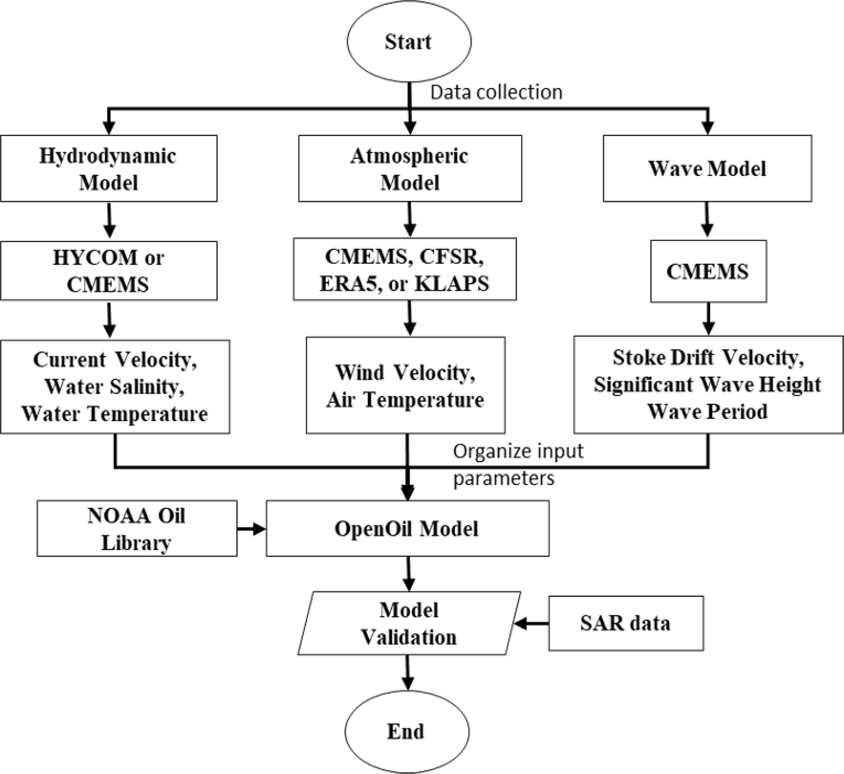
Fig. 1 presents the flow chart of the proposed methodology. HYCOM and CMEMS were used as hydrodynamic models to provide ocean current parameters. The wind data are received from CMEMS, CFSR, ERA5, and KLAPS models, while CMEMS models are also used to extract the wave parameters. Six combinations were suggested to evaluate the most effective input forcing parameters for simulating spilled oil transport on the ocean surface. The characteristics of oil types were identified using the NOAA oil library. Finally, the met-ocean forcings and oil-type information were used to drive the OpenOil model. The performance of each combination is rigorously assessed by comparing the results with synthetic aperture radar (SAR) observation data at a specific time.

3. Numerical Setup for Hebei Spirit Accident

3.1 Hebei Spirit Accident

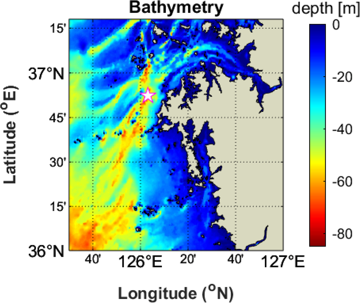
On the morning of December 7, 2007, at 7:15 (local time), the very large oil crude oil carrier (VLLC) Hebei Spirit collided with Samsung cranes near the latitude and longitude of 36° 49.93’ N, 126° 2.46’ E, located approximately 10 km off the Taean coasts, leaking approximately 10,900 t of crude oil. Fig. 2 presents the site location for the spilled oil slick. The Korean Coast Guard (KCG) report indicates that strong northwestern currents and winds blow oil slick transport along approximately 375 km of the west coast of Korean coastlines, heavily contaminating 70 km of the Taean peninsula with crude oil. Remarkably, the oil slick quickly reached the Taean shoreline at 13 h, which was significantly shorter than the predicted time of approximately 24 h, as suggested by the Ministry of Oceans and Fisheries (MOF) (Lee et al., 2020). In particular, oil slicks polluted large areas of the open sea and contaminated Jeju Island, the southern end of the Korean Peninsula (Kim et al., 2014).
The oil slick transport resulting from the Hebei Spirit accident was simulated for five days from 2007/12/07 at 07:15 to 2007/12/07 at 11:00 am. The oil type used in the OpenOil model was Kuwait export crude, with a density of 820.5 kg/m3 as the representative oil type. Approximately 10,900 oil particles were initially set up. The Openoil model was coupled with the real-time current circulation data from the HYCOM and CMEMS models, winds from CFSR, ERA5, CMEMS, and KLAPS, and waves from CMEMS. Table 4 lists the initial input parameters for the oil slick simulation in the Hebei Spirit accident.

3.2 Simulation of Current, Wind and Wave Fields

The study area on the eastern Yellow Sea is characterized by relatively shallow waters with a water depth of less than 60 m. On the other hand, the topography near the Taean coast is approximately 25 m deep (Fig. 2). Fig. 3 shows the wind velocity fields obtained from CMEMS, CFSR, ERA5, and KLAPS models on December 7, 2007 at 7:15 am. The color map indicates the wind velocity magnitude measured 10 m above the sea water level, and the blue arrows represent the wind direction. The wind fields in the Korean Peninsula follow the characteristics of the seasonal wind areas of Asia. The spring and summer seasons witnessed south/southwestern winds, but the main north/northwestern winds primarily blow in the autumn and winter seasons. Therefore, in the Hebei Spirit accident, the north and northwestern wind fields were recorded with their speed reaching a maximum of approximately 14 m/s (Fig. 3). Similarly, for the wind dataset derived from four meteorological models, while approximately less than 6 m/s of wind velocity speed was measured generally close to the Tean coastlines, the wind velocity exceeds 10 m/s in the open sea.
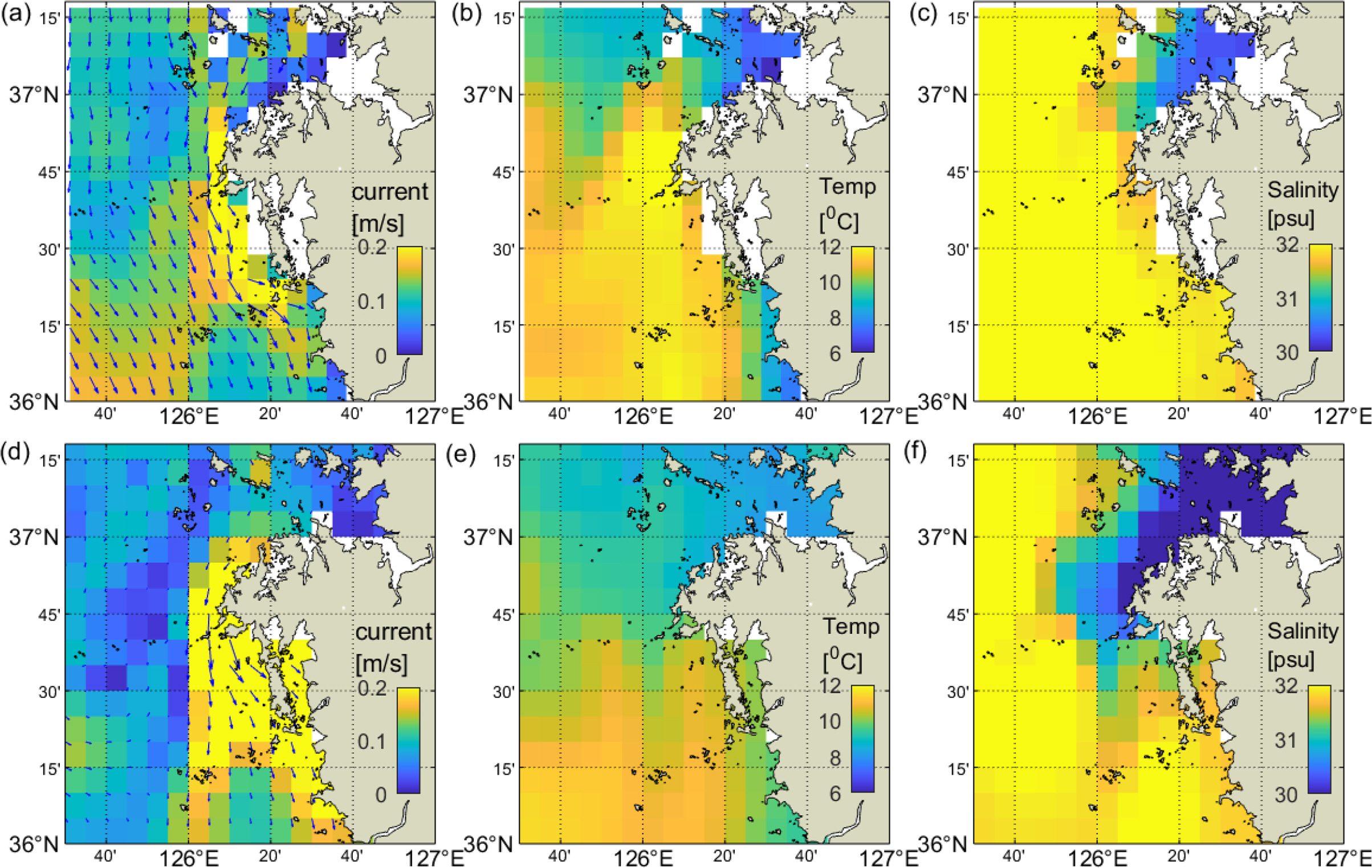
Fig. 4 presents the current circulation parameters, including the current field velocity, sea surface salinity, and sea surface temperature extracted from the HYCOM and CMEMS models. The current velocity ranged from 0.1 m/s to 0.6 m/s in the northwest direction. A slight difference in current velocity was measured near the Taean peninsula. On the other hand, a significant difference is observed in the open sea because HYCOM measured the current parameters every three hours, while the daily dataset was recorded in the CMEMS model. Moreover, the sea surface temperature and salinity magnitude were up to 12°C and 32 psu, respectively.
Keramea et al. (2023) comprehensively reviewed the operation and forcing in oil spill models. The literature review showed that only seven case studies of oil spill simulations were conducted while considering adequate met-ocean data as input parameters. Most studies focused on forecasting hydrodynamic ocean current and meteorological models as met-ocean input parameters while neglecting the wave fields model, represented by the significant wave height, wave period, and Stoke drift velocities, in oil spill models. This limitation may influence the oil slick transport on the ocean surface. Fig. 5 shows the Stoke drift velocities, significant wave height, and period received from the CMEMS model. The maximum significant wave height was approximately 3 m with a wave period of 6.5 s when the accident occurred. Moreover, the Stoke drift velocities ranged from 0.03 m/s to 0.2 m/s in the northwest direction.

4. Numerical Results and Discussion

The oil spill model, OpenOil, was used to simulate oil slick diffusion along the Taean coasts during the Hebei spirit accident. The numerical model was coupled with met-ocean factors of currents, winds, and waves, which were organized into six combinations. The simulation duration was five days, from December 7, 2007, to December 11, 2007. The resulting distribution of spilled oil on the sea surface of each combination was compared with the satellite observation results at 10:40, December 11, 2007. The predictive performance of each combination was evaluated through the matching rate between simulated and observed results, suggesting the most effective combination in simulating oil spill transport in the Korean Peninsula.

4.1 Numerical Model Results

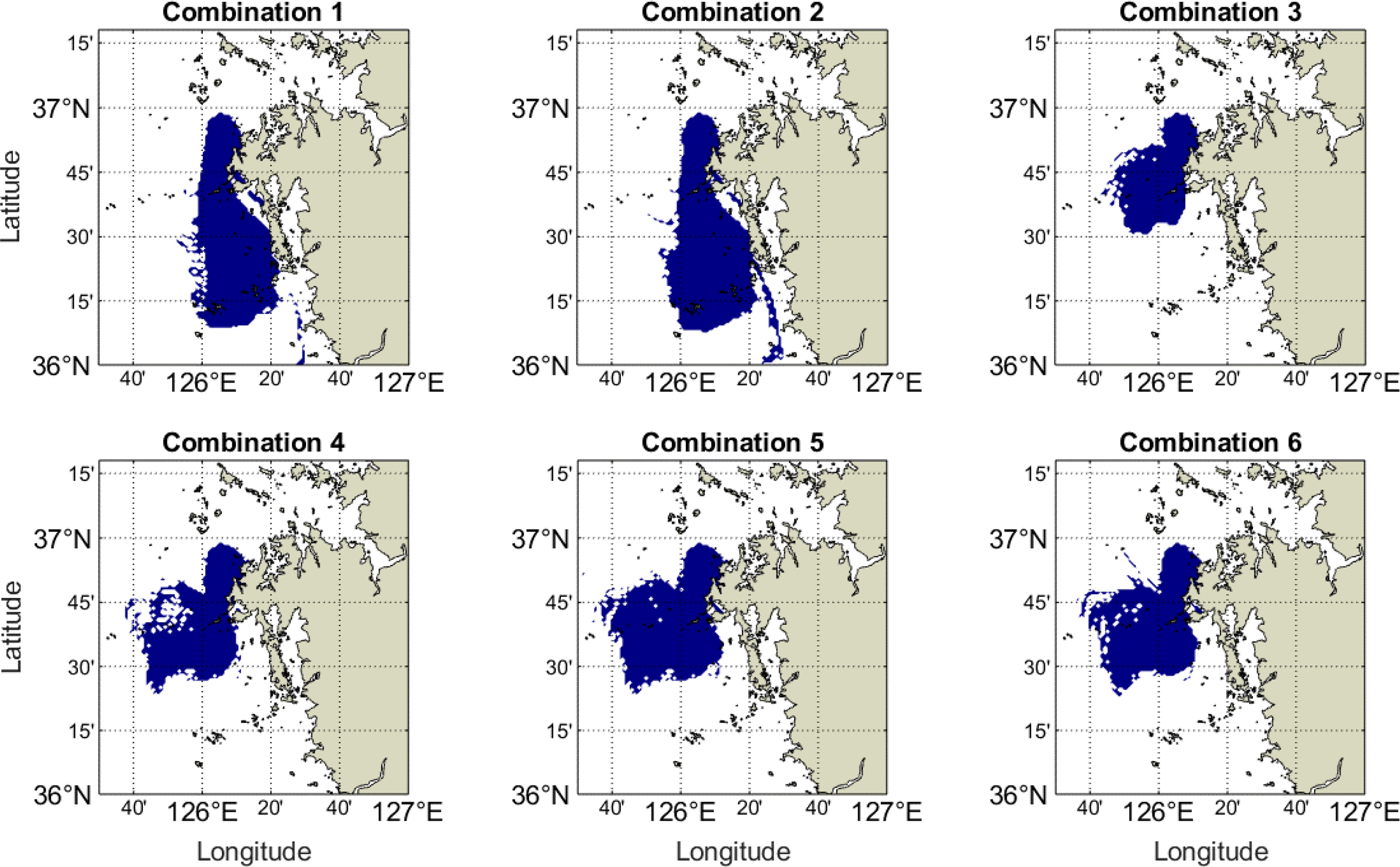
Fig. 6 shows the distribution of oil slick on the sea surface after 99.2 h from the accident. The movement of spilled oil showed good agreement with the current and wind directions presented in Figs. 3 and 4. There are two clear trends for oil diffusion using CMEMS (combinations 1 and 2) and HYCOM models (combinations 3, 4, 5, and 6) as hydrodynamic ocean circulation models in the oil spill model. In combinations 1 and 2, a slight difference is observed in the spilled oil distribution, in which the oil slick moved approximately 92 km from the Taean coast to the Maryang-ri port. By contrast, the combinations from 3 to 6 showed that the distribution of spilled oil slicks ranged from approximately [125.6°–126.1°E] for longitude and [36.4°–36.96°N] for latitude. Table 5 lists the specific dimensions in terms of width and length, as well as the projected area of oil slicks in each combination.

4.2 Numerical Model Validation

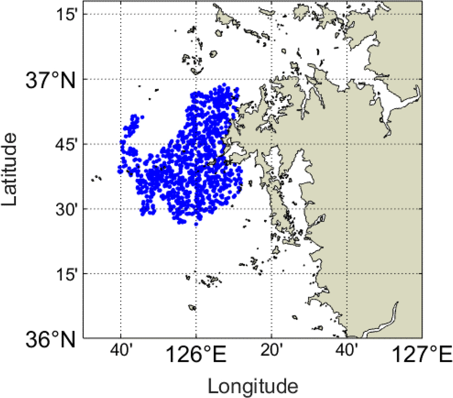
The numerical results are validated by comparing the simulated distribution of oil slicks with the observed results obtained from Envisat ASAR at 10:40 on December 11, 2007, for the Hebei Spirit accident. The observation satellite image was processed using the adaptive threshold method (Fig. 7). The significant oil slicks extended longitudinally from 125.6°E to 126.3°E and latitudinally from 36.43°N to 36.99°N, encompassing maximum widths and lengths of 62.27 km and 62.63 km, respectively, and spanning an approximate area of 1600 km2. Generally, configurations incorporating the HYCOM model as a hydrodynamic input showed reasonable agreement with the observed oil slick distribution in both spatial dimensions and projected area, exhibiting a deviation of less than 20% compared to configurations using CMEMS models, which displayed a maximum difference of 50%.
Kim et al. (2014) proposed a thorough validation approach for oil slick movement, enabling users to evaluate the performance of each combination (Fig. 8). First, the study area was divided into grid cells, each measuring 0.5 km × 0.5 km. The second step was to identify each cell containing oil particles in both simulated and observed oil slicks, with blue for the numerical result and pink for the observation result. Subsequently, the overlapped cells between simulated and observed results are extracted. To calculate the percentage of similarity between numerical and SAR results, a matching percent is introduced, which is determined by the fraction between the total number of overlapped cells and the total number of observation cells containing oil particles. Fig. 9 compares the matching percent in each combination with observed results. In the presence of the CMEMS hydrodynamic models, the match percentage was approximately 53%, while the HYCOM hydrodynamic models induced matching rate values from 70% to 88%, indicating a much higher accuracy than the CMEMS combinations. Therefore, the HYCOM model is more effective than the CMEMS model in contributing hydrodynamic ocean circulation parameters for oil spill models. Moreover, significant improvements in matching percentages were observed when a high-resolution meteorological dataset was introduced for HYCOM combinations. For CFSR (spatial resolution ∼56 km), the matching percentage was only 70%, which increased to approximately 86% for the ERA5 and CMEMS meteorological models (~27 km) and 88% for the KLAPS model (~5 km). Therefore, increasing the resolution of forecasting met-ocean models is necessary to enhance the performance of numerical models to predict the spilled oil diffusion on the sea surface. Furthermore, the notable precision exhibited by the HYCOM model in simulating the transport of oil slicks underscores the potential for widespread adoption of HYCOM met-ocean datasets coupling with different atmospheric models across the Korean peninsula.

4.3 Discussion

The spatial and temporal resolution of met-ocean models significantly influences the accuracy of numerical results in oil spill simulations. Most hydrodynamic, meteorological, and wave models are extracted from open-source global-scale models with coarse resolutions. This highlights the need for further investigation on implementing regional models for oil spill models. The KOOS was established at the KIOST to provide real-time observations and simulated datasets of ocean fields in multiple scales. The KOOS dataset provides waves, currents, sea surface salinity, water temperature, and wind fields, updated twice daily for 72 hours (Park et al., 2015). The system collects observation datasets from real-time marine monitoring platforms. This information was used to calibrate the numerical models. Park et al. (2015) also implemented a 300-m horizontal resolution of atmospheric variables (wind components and atmospheric temperature), current and wave variables (current velocity, water temperature, salinity, and elevation) into the oil spill model, MOHID to simulate the oil spill transport at a quay off Yeosu port. The numerical results effectively replicated the spilled oil transport and satisfied the general acceptable criteria. The KOOS data have been under development since August 2009 by KIOST, and the dataset has not been applied to simulate the Hebei Spirit accident. Nevertheless, the current study suggests that KOOS data can be used to simulate the oil slick transport released from recent accidents and in further research aimed at improving spill modeling.

5. Conclusions

This study conducted a comprehensive examination of the transport of spilled oil slicks resulting from the Hebei Spirit accident, using the OpenOil numerical model operationally coupled with various forecasted met-ocean models. The key findings of this research are summarized as follows:
  • (1) An extensive literature review was conducted to assess the availability of forecasted met-ocean datasets, which included meteorological models (CMEMS, CFSR, ERA5, and KLAPS), hydrodynamic current circulation models (HYCOM and CMEMS), and a wave model (CMEMS) that can be used as input parameters for simulating the 2007 Hebei Spirit oil spill accident.

  • (2) Six combinations were tested in OpenOil, incorporating these met-ocean datasets to simulate the transport of the oil slick over five days, spanning from December 7, 2007, to December 11, 2007. The numerical results showed that the selection of hydrodynamic ocean models significantly influenced the distribution of the oil slick. In particular, the hydrodynamic variables derived from the HYCOM model outperformed those from the CMEMS model in replicating the oil slick area compared to the observed dataset, with distribution areas of 1991 km2 (combination 6) and 3155 km2 (combination 1) compared to the observed oil slick area of 1600 km2.

  • (3) Further validation was carried out by identifying the overlapping cells between the simulated and observed oil slicks on the sea surface. The CMEMS-based combinations exhibited a similarity of 53%, while the HYCOM-based combinations displayed matching percentages ranging from 70% to 88% compared to the SAR-observed oil slicks.

This study provided a comprehensive assessment of the performance of each met-ocean dataset in predicting oil spill transport in the Korean Peninsula. These results highlight the significant impact of the quality of met-ocean datasets on the results of spilled oil distribution. Further research should explore the use of high-resolution KOOS datasets for simulating oil spill transport in the Korean Peninsula. This could contribute to more accurate and reliable oil spill modeling in the region.

Conflict of Interest

Sungwon Shin serves as an editorial board member of the Journal of Ocean Engineering and Technology but played no role in deciding the publication of this article. No potential conflicts of interest relevant to this study are reported.

Funding

This study was based upon work supported by the Korean Evaluation Institute of Industrial Technology (KEIT) grant funded by the Korean government (KCG, MOIS, NFA) [RS-2022-001549812, Development of technology to respond to marine fires and chemical accidents using wearable devices] and Korean Institute of Marine Science & Technology Promotion (KIMST) funded by the Ministry of Oceans and Fisheries, Korea (No. RS-2023-00256687).

Fig. 1.
Flow chart of the proposed methodology
ksoe-2024-043f1.jpg
Fig. 2.
Bathymetry of Taean coasts for oil spill transport and position of accident (markered star)
ksoe-2024-043f2.jpg
Fig. 3.
Computational wind field velocity derived from CMEMS (a), CFSR (b), ERA5 (c), and KLAPS (d) models on December 7, 2007, at 7:00 am.
ksoe-2024-043f3.jpg
Fig. 4.
Computational current field velocity (a, d), sea surface temperature (b, e), and sea surface salinity (c, d) derived from HYCOM (top) and CMEMS (bottom) models on December 7, 2007 at 7:00 am.
ksoe-2024-043f4.jpg
Fig. 5.
Computational Stoke Drift field velocity (a), significant wave height (b), and wave period (c) derived from CMEMS model on December 7, 2007 at 7:00 am.
ksoe-2024-043f5.jpg
Fig. 6.
Oil slick transport distribution acquired over six combinations at 10:40 am, December 11, 2007.
ksoe-2024-043f6.jpg
Fig. 7.
Oil slick transport distribution measured by SAR observation acquired at 10:40 am, December 11, 2007.
ksoe-2024-043f7.jpg
Fig. 8.
Flow chart of the model validation process.
ksoe-2024-043f8.jpg
Fig. 9.
Matching percentage between six combinations and observation results
ksoe-2024-043f9.jpg
Table 1.
Hydrodynamic ocean model
Meteorological models Organizer Spatial resolution Temporal resolution
CFSR NCEP 1/2° 1-hourly
ERA5 ECMWF 1/4° 1-hourly
CMEMS CMEMS 1/8°, 1/4° 1-hourly
KLAPS KMA 1/20° 1-hourly
Table 2.
Hydrodynamic ocean models
Hydrodynamic models Organizer Spatial Resolution Temporal resolution
CMEMS CMEMS 1/12° Daily
HYCOM NOAA 1/12° Three-hourly
Table 3.
Tested combination considering input variables applied in the OpenOil model
Combination tests Hydrodynamic model Meteorological model Wave model Salinity temperature
Combination 1 CMEMS CMEMS CMEMS CMEMS
Combination 2 CMEMS ERA5 CMEMS CMEMS
Combination 3 HYCOM CFSR CMEMS CMEMS
Combination 4 HYCOM ERA5 CMEMS HYCOM
Combination 5 HYCOM CMEMS CMEMS HYCOM
Combination 6 HYCOM KLAPS CMEMS HYCOM
Table 4.
Initial conditions of the test cases
Initial conditions Setup
Position 36° 49.93’ N – 126° 2.46’ E
Start time of simulation 2007/12/07
End time of simulation 2007/12/11
Simulation duration Five days
Oil type Kuwait export crude
Spill amount (t) 10,900
Model time step (s) 3,600
Output time interval (s) 3,600
Number of particles 10,900
Area coverage [125.5° 127°] – [36° 37.3°]
Hydrodynamic data HYCOM, CMEMS
Atmospheric data CMEMS, CFSR, ERA5, KLAPS
Wave data CMEMS
Table 5.
Spilled oil distribution over six combinations
Dimensions Combination 1 Combination 2 Combination 3 Combination 4 Combination 5 Combination 6
Width (km) 44 69 41 48 56 50
Length (km) 92 92 51 66 60 62
Area (km2) 3155 3183 1131 1965 2056 1991

References

Abascal, A. J., Castanedo, S., Núñez, P., Mellor, A., Clements, A., Pérez, B., & Medina, R. (2017). A high-resolution operational forecast system for oil spill response in Belfast Lough. Marine Pollution Bulletin, 114(1), 302-314. https://doi.org/10.1016/j.marpolbul.2016.09.042
crossref pmid
Abdallah, I. M., & Chantsev, V. Y. (2022). Simulating oil spill movement and behavior: a case study from the Gulf of Suez, Egypt. Modeling Earth Systems and Environment, 8(4), 4553-4562. https://doi.org/10.1007/s40808-022-01449-9
crossref
Androulidakis, Y., Kourafalou, V., Robert Hole, L., Le Hénaff, M., & Kang, H. (2020). Pathways of oil spills from potential Cuban offshore exploration: Influence of ocean circulation. Journal of marine science and engineering, 8(7), 535. https://doi.org/10.3390/jmse8070535
crossref
Dang, H. V., Shin, S., Lim, J., Joo, S., & Hur, J. (2023). Numerical model test of spilled oil transport near the Korean coasts using various input parametric modules. The proceedings of 2023 Fall Conference of the Korea Society of Ocean Engineering (KSOE).

De Dominicis, M., Bruciaferri, D., Gerin, R., Pinardi, N., Poulain, P. M., Garreau, P., & Manganiello, C. (2016). A multi-model assessment of the impact of currents, waves, and wind in modelling surface drifters and oil spill. Deep Sea research part II: topical studies in oceanography, 133, 21-38. https://doi.org/10.1016/j.dsr2.2016.04.002
crossref
De Dominicis, M., Pinardi, N. A. D. I. A., Zodiatis, G., & Archetti, R. J. G. M. D. (2013). MEDSLIK-II, a Lagrangian marine surface oil spill model for short-term forecasting–Part 2: Numerical simulations and validations. Geoscientific Model Development, 6(6), 1871-1888. https://doi.org/10.5194/gmd-6-1871-2013
crossref
French-McCay, D. P., Spaulding, M. L., Crowley, D., Mendelsohn, D., Fontenault, J., & Horn, M. (2021). Validation of oil trajectory and fate modeling of the Deepwater Horizon oil spill. Frontiers in Marine Science, 8, 618463. https://doi.org/10.3389/fmars.2021.618463
crossref
Hole, L. R., Dagestad, K. F., Röhrs, J., Wettre, C., Kourafalou, V. H., Androulidakis, Y., Kang, H., Le Hénaff, M., & Garcia-Pineda, O. (2019). The Deepwater Horizon oil slick: simulations of river front effects and oil droplet size distribution. Journal of marine science and engineering, 7(10), 329. https://doi.org/10.3390/jmse7100329
crossref
Jung, T. H., & Son, S. (2018). Oil spill simulation by coupling three-dimensional hydrodynamic model and oil spill model. Journal of Ocean Engineering and Technology, 32(6), 474-484. https://doi.org/10.26748/KSOE.2018.32.6.474
crossref
Keramea, P., Kokkos, N., Gikas, G. D., & Sylaios, G. (2022). Operational modeling of North Aegean oil spills forced by real-time met-ocean forecasts. Journal of Marine Science and Engineering, 10(3), 411. https://doi.org/10.3390/jmse10030411
crossref
Keramea, P., Kokkos, N., Zodiatis, G., & Sylaios, G. (2023). Modes of operation and forcing in oil spill modeling: state-of-art, deficiencies and callenges. Journal of Marine Science and Engineering, 11(6), 1165. https://doi.org/10.3390/jmse11061165
crossref
Kim, J. C., Yu, D. H., Sim, J. E., Son, Y. T., Bang, K. Y., & Shin, S. (2023). Validation of opendrift-based drifter trajectory prediction tTechnique for maritime search and rescue. Journal of Ocean Engineering and Technology, 37(4), 145-157. https://doi.org/10.26748/KSOE.2023.018
crossref
Kim, T. H., Yang, C. S., Oh, J. H., & Ouchi, K. (2014). Analysis of the contribution of wind drift factor to oil slick movement under strong tidal condition: Hebei Spirit oil spill case. PloS one, 9(1), e87393. https://doi.org/10.1371/journal.pone.0087393
crossref pmid pmc
Korean Coast Guard (KCG). (2021). Korea Coast Guard Annual Report, https://www.kcg.go.kr/ebook/whitebook/2020/index.html

Law-Chune, S., Aouf, L., Dalphinet, A., Levier, B., Drillet, Y., & Drevillon, M. (2021). WAVERYS: a CMEMS global wave reanalysis during the altimetry period. Ocean Dynamics, 71, 357-378. https://doi.org/10.1007/s10236-020-01433-w
crossref
Lee, K. H., Kim, T. G., & Cho, Y. H. (2020). Influence of tidal current, wind, and wave in Hebei Spirit oil spill modeling. Journal of Marine Science and Engineering, 8(2), 69. https://doi.org/10.3390/jmse8020069
crossref
Meza-Padilla, R., Enriquez, C., & Appendini, C. M. (2021). Rapid assessment tool for oil spill planning and contingencies. Marine Pollution Bulletin, 166, 112196. https://doi.org/10.1016/j.marpolbul.2021.112196
crossref pmid
Nguyen, T. H. H., Hou, T. H., Pham, H. A., & Tsai, C. C. (2023). Hindcast of oil spill pollution in the East China Sea in January 2018. Proceedings of the Institution of Mechanical Engineers, Part M: Journal of Engineering for the Maritime Environment. 14750902231162171. https://doi.org/10.1177/14750902231162171
crossref
Park, K. S., Heo, K. Y., Jun, K., Kwon, J. I., Kim, J., Choi, J. Y., & Jeong, S. H. (2015). Development of the operational oceanographic system of Korea. Ocean Science Journal, 50, 353-369. https://doi.org/10.1007/s12601-015-0033-1
crossref
Röhrs, J., Dagestad, K. F., Asbjørnsen, H., Nordam, T., Skancke, J., Jones, C. E., & Brekke, C. (2018). The effect of vertical mixing on the horizontal drift of oil spills. Ocean Science, 14(6), 15811601. https://doi.org/10.5194/os-14-1581-2018
crossref
Sepp Neves, A. A., Pinardi, N., Navarra, A., & Trotta, F. (2020). A general methodology for beached oil spill hazard mapping. Frontiers in Marine Science, 7, 65. https://doi.org/10.3389/fmars.2020.00065
crossref
Siqueira, P. G. S. C., Silva, J. A. M., Gois, M. L. B., Duarte, H. O., Moura, M. C., Silva, M. A., & Araújo, M. C. (2022). Numerical simulations of potential oil spills near Fernando de Noronha archipelago. Trends in Maritime Technology and Engineering, 273-282.
crossref
Zacharias, D. C., Gama, C. M., Harari, J., da Rocha, R. P., & Fornaro, A. (2021). Mysterious oil spill on the Brazilian coast–part 2: a probabilistic approach to fill gaps of uncertainties. Marine pollution bulletin, 173, 113085. https://doi.org/10.1016/j.marpolbul.2021.113085
crossref pmid
Zhang, X., Cheng, L., Zhang, F., Wu, J., Li, S., Liu, J., & Li, M. (2020). Evaluation of multi-source forcing datasets for drift trajectory prediction using Lagrangian models in the South China Sea. Applied Ocean Research, 104, 102395. https://doi.org/10.1016/j.apor.2020.102395
crossref
TOOLS
Share :
Facebook Twitter Linked In Google+ Line it
METRICS Graph View
  • 0 Crossref
  •   Scopus
  • 499 View
  • 16 Download


ABOUT
BROWSE ARTICLES
ARTICLE CATEGORY

Browse all articles >

PUBLICATION ETHICS
FOR CONTRIBUTORS
Editorial Office
President Office BD Rm. 1302, 13 Jungang-daero 180beon-gil, Dong-gu, Busan 48821, Republic of Korea
Tel: +82-51-759-0656    Fax: +82-51-759-0656    E-mail: ksoehj@ksoe.or.kr                

Copyright © 2024 by The Korean Society of Ocean Engineers.

Developed in M2PI

Close layer
prev next